Harnessing GPS and computer technology “With Global Positioning System (GPS) signals pilots can now know exactly where they are. Add super-accurate terrain databases and graphical displays and we can now draw three-dimensional moving scenes that will show pilots exactly what’s outside," Michael Lewis, director of NASA’s Aviation Safety Program, said some years ago in relation to SVT. "The type of accidents that can happen in poor visibility just don’t happen when pilots can see the terrain hazards outside.”
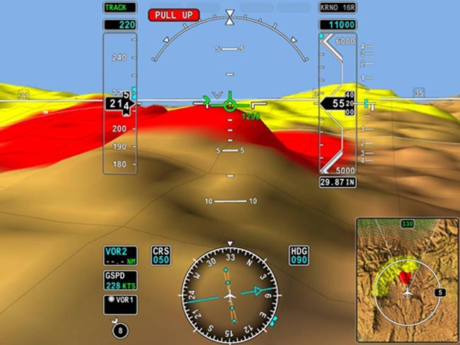
SVT pictorially depicts on liquid-crystal flat-panel displays what pilots see poorly or not at all outside the cockpit, depending on the weather conditions and amount of light. GPS and advanced computer technologies have made it possible for land, bodies of water, obstacles and other aircraft to be displayed on primary flight displays (PFDs), also known as pilot flight displays.
Synthetic vision uses terrain, obstacle, hydrological and other databases. Updates are issued to pilot-owners and flight departments every 28, 56, or 365 days, depending on whether the database is related to air navigation, runways, taxiways and other airport surfaces, or terrain and man-made obstacles.
On the ground and during flight, the aircraft’s position is constantly updated via an onboard GPS receiver that interfaces with the SVT system.
Optional or standard equipment
Depending on the airplane manufacturer, SVT is either optional or standard equipment. For private-jet makers Cessna, Gulfstream, Bombardier/Learjet, Dassault Falcon Jet, and Embraer, SVT is optional. The cost starts at approximately $250,000.
Various aerospace companies are in the process of obtaining FAA approval to retrofit turbine aircraft such as the Beech King Air 300 and Canadair Challenger 600 with SVT.
Diamond Aircraft Industries (DAI) announced in April that its single-piston-engine DA40 Diamond Star airplane would be equipped with the Garmin G1000 SVT system for $9,995.
Referring to the G1000 avionics, DAI said, “Land, water and sky are clearly differentiated with shading and textures that are similar to the topographical colors found on the multi-function display moving map. SVT works seamlessly to alert pilots of potential ground hazards by displaying terrain and obstacles which pose a threat to the aircraft with appropriate TAWS (Terrain Alert Warning System) coloring. Other SVT features include a display of traffic on the PFD, obstacle displays which enlarge intuitively as the aircraft approaches them, and other useful tools like Pathways’ ‘flying rectangles’ which help the pilot stay on course whether flying en route legs or on arrivals, departures and approaches.”
Chelton Flight Systems has developed SVT for various Bell helicopter models and Boeing has done the same for various types of military rotary-wing aircraft, including the CH-47 Chinook, AH-64 Apache and V-22 Osprey.
Because of the significant benefits of SVT, synthetic vision systems are expected to become common in aircraft.
In June 2006, Randy Robertson, vice president of engineering for Honeywell Aerospace, a major SVT manufacturer, said, “Flying with synthetic vision 10 years from now is going to be like flying with an HSI (horizontal situation indicator) today. It’s going to be commonplace in general aviation and second nature for tomorrow’s pilots.”